
Those who slogged through my previous memoir, “The Great Dismal Swamp” know that after many youthful adventures in that marvelous morass it was time for me to grow up and see the world. After fits and starts as a freelance waterfall builder I had some success and purchased the first five acres of what would become Weazelworld, but later fell afoul of the taxman. Effectively destitute after the tax settlement, I decided to seek my fortune abroad, but where? This is the story of my adventures in the Orient during the years 1987 and 1988. Be prepared for shifty Chinese businessmen, mad orchid thieves, Christian headhunters, and bloodthirsty leeches!
A note to readers: My adventures during this period of my life are poorly documented. My notes are either non existent or in disarray, and the few photos that remain are mottled with mildew from the jungle damp.
In the fall of 1986 the taxman came to the door of the dilapidated trailer that I had purchased for $10 to make what he called, “an assessment”, a procedure which I confused with an audit. The agent was there because I had turned myself in for tax evasion and was taking advantage of an amnesty. He was a pallid, pimply, pencil necked geek in an ill fitting suit, a young newly minted agent of the IRS.
His fear was palpable. It was obvious that he had never ventured so far into the woods and expected to be murdered and buried in a shallow grave, much as one might expect in a grade B “Cabin in the Woods” horror movie. His hands shook as he mounted the steps.

He looked around in dismay at the squalor of my living conditions, then summoned his courage to boldly ask, “What is the value of your TV set”. I laughed and asked him if he was hallucinating due to drugs for there was no TV set to be seen. He protested that as an agent of the United States government he would never take drugs. He was there to make an “assessment” of the total value of all of my possessions. My lack of a TV was incomprehensible. He had a paper form on a clipboard with boxes to be checked, and the presumption was that all Americans had a TV. He had to leave the first box empty, and feared censure from the bean counters back at the office.
I pointed to my little desk which I described as “the nerve center of my empire”, and said that it cost $5 at a yard sale. Then I gestured at the wooden planking held up by cinder blocks where I stored my non existent business records. “I don’t remember the cost per board foot of the planking, but the cinder blocks cost $0.57 apiece. You can count them yourself. As for the couch, it got it for free but it is covered with semen so you might not want to touch it.” He didn’t.
I told him that the big dollar items were in the kitchen. The kitchen table cost $10, and the stove and fridge together cost $75. He dutifully enter the information into his form.
He rallied and whirled about to ask, “How much did you pay for your trailer?” I told him ten dollars and produced a notarized bill of sale. He became disoriented and trembled even harder. Things were not going as planned and most of his check boxes were empty.
We proceeded down the hall. The first room was filled waist deep with worn out jungle boots and broken fishing rods. I proudly proclaimed that Imelda Marcos had nothing on me, my collection of jungle boots was world class!
The second room was where I kept the drawing table to prepare plans for my waterfalls. At the moment it was inaccessible due to an avalanche of Tolstoy books. The weight of his complete works, and the planks and cinder blocks that held them up, had collapsed the floor of the trailer and were blocking the door. He peered through the rubble and asked, “What is a Tolstoy?”
He peered through the rubble and asked, “What is a Tolstoy?”
The only place left was the bedroom, a place that even I thought was scary. He glanced in, then turned and ran for the front door.
Once safely outside he stood there trembling with his boxes unchecked then spied my canoe. “What is the value of your yacht Sir?” I explained that my mother had given me the canoe on my 16th birthday. “No, I mean your motor boat, your cabin cruiser.” I had no such boat so once again the box was left unchecked.
He was utterly flabbergasted. “According to your bank records you brought in $312,000 in 1986.” I said that was true, but that the vast majority of the money had been spent on materials, equipment, and labor to build waterfalls. At that point he actually did me a favor by saying, “Do not mention labor costs again unless you paid withholding taxes on the men. You may have successfully gamed the system by turning yourself in for tax evasion, but if you failed to pay withholding that is a separate felony and you will go to prison.” I took his advice and stopped talking about labor costs.
His mission had thus far been a complete failure. The total value of all my possessions amounted to almost nothing. I actually felt sorry for him. He was a new IRS agent and he had failed to terrorize me as he had been trained to do. I asked how much I owed and he replied, “Approximately one third of everything you own. That should be around $90,000.”
He gasped in disbelief as I smiled and wrote out a check for $90,000. In the history of IRS lore no one in my lowly position had ever paid such a sum without bankruptcy or a lengthy court battle. The tremor returned to the hand that held the check.
He gathered his thoughts, looked around, then asked, “With all that money why do you live this way?” It was a valid question.
I replied, “Every day you wake up dreading what will happen next. You go to your office, a place you hate where everyone hates you. Your poorly paid job is to do hateful things to people you don’t even know, like me. Then you go home to watch TV and try not to ponder the emptiness of your life.”
“I don’t care about either money or possessions. I live for adventure. Now that you have robbed me of $90,000 I am going to scrape together my few remaining dollars and go to southeast Asia. Once there I intend to take some great drugs, screw some young diagonal pussy, and enjoy drinks with umbrellas while laying on the beach. Meanwhile, you will be repeating the routine I just mentioned. I may or may not return.” On unsteady legs he staggered back to his car, glad to have survived a meeting with a mad man. His boxes may have been unchecked, but he had a check for $90,000.
On unsteady legs he staggered back to his car, glad to have survived a meeting with a mad man. His boxes may have been unchecked, but he had a check for $90,000.
……………………………………….
In the days before computers it was difficult to acquire information about business leads. I used the Engineering News Record, a publication intended for the titans of business which made brief reference to big deals around the world. In my perusal I repeatedly noticed an entity named Kuok. I didn’t know if Kuok was a person, a business, or an acronym. Whoever or whatever it was, it was big. I learned that Robert Kuok was a Malaysian Chinese tycoon. He and his eponymous company controlled the world’s sugar market. They were shipping magnates who had built a vast real estate empire in places like Hong Kong, Singapore, and mainland China. Building requires architects, and I was practiced at dealing with architects. It was the lead I needed.
Further research tied Kuok to the architectural firm of Wong and Tung. I had no idea where Kuok was located, but I was delighted to discover that Wong and Tung had an office in Dallas. I bought an open airline ticket around the world and headed west.
In Dallas, a loathsome place, I rented a car and went in search of Mr. Wong with whom I had arranged a meeting. I supposed that such an important architect would have a big office in a high rise. I was dismayed to discover that his office was in a dilapidated old building in a run down neighborhood.
I opened the door but no one was there. Perhaps the receptionist was out to lunch? But where was everyone else? There was nothing to do but sit and wait.
The walls were covered with what appeared to be architectural models of enormous complexes superimposed on imaginary landscapes. The buildings were hideous, countless identical towers rising from vast featureless podia, a vision of an urban hellscape if ever there was one. Architects often display models of buildings they designed but were never built. That is what I thought I was looking at.
Eventually a doddering old Chinese man emerged from the back. “Ah, Mr. Morgan, so glad to see you. I had forgotten our appointment. What can I do for you?”
I explained that I was an environmental artist and waterfall builder who wanted to seek my fortune in the Orient.
I explained that I was an environmental artist and waterfall builder who wanted to seek my fortune in the Orient. I had heard that he was involved in large scale residential projects so perhaps I could be of some service. I showed him my portfolio, then asked to see some examples of his work.
He indignantly asked, “Didn’t you look at those photos all over the walls?” I said yes, I had looked at the models, but I wanted to see the real things. He was affronted. “Those are the real things!” I protested that such enormous building couldn’t possibly exist.
He asked that I look more closely at a photo of the Mei Foo Sun Chuen residential complex in the New Territories of Hong Kong. It featured 99 identical towers and was intended to house 80,000 inhabitants.
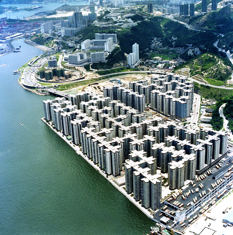
As we leaned toward the photos he exploded with rage. “Do you see those tiny white dots? That is drying laundry. It is forbidden to hang laundry out of the windows. It ruins my building! Furthermore, there are over 90,000 people living there, more than is allowed! Next, they will have dogs and cats!”

I could hardly believe it, but there was the proof. It was a real place. How was it possible for over 90,000 people to live in one building? As for the missing staff he explained that all architectural work was done in China where draftsmen were dirt cheap. He only had an office in Dallas because it was a legal requirement for projects in the US.
I asked about artwork and landscape features. There appeared to be none, just concrete. He explained that there were planters on the podium. They were only one square meter in size so they were invisible at the scale of the photo.
He said that the inhabitants often got lost among the 99 identical towers. Many were illiterate peasants from rural China so the towers were identified by hideous modern sculptures of familiar things like chickens, fish, etc. That way a lost granny could ask, “Which way to the giant rooster?” To my delight he offered to introduce me to the Kuok brothers.
It was my first glimpse of Hong Kong. I feared the worst, but it proved to be a most interesting place.
……………………………………………………….
Jet lag is hell. I awoke at 4am in a fire prone walk up flophouse in Kowloon, the only thing I could afford. The traffic roared, for Hong Kong never sleeps. There was nothing to do but get up before dawn to explore the city.
I wandered south down the Kowloon peninsula, totally astounded by the human density and exuberant capitalism. All the buildings were high rise hives that appeared ready to either burn or collapse during the next typhoon. Brightly colored advertising banners with Chinese calligraphy hung everywhere. The streets were filled with taxis threatening to run down hunched over peasants wheeling their vegetable carts through the darkened streets.

Everything is for sale in Hong Kong. Weeks later while walking down Shanghai street I found a fellow who had spread out a blanket covered in Buddhist relics looted from Tibet which was then being invaded and crushed by China. I bought a silver covered human thighbone censer, and the silver encrusted skulls of two holy men. I still have one of the skulls and have shown it much greater respect than the Chinese ever would have.
Dawn was breaking as I arrived at the southern end of the peninsula overlooking Victoria harbor and the island of Hong Kong. (Kowloon is on the mainland, Hong Kong is an island.) It was a scene that I will never forget.

The harbor was crowded with ships and boats of every description. There were supertankers, naval destroyers, luxury sailing yachts, speedboats, ancient Chinese junks, and little lumbering sampans that traversed the harbor at their peril.
Behind it all was the magnificent island of Hong Kong with skyscrapers in the foreground and the mist shrouded slopes of Victoria peak beyond. It was like a dream.

The first ferry of the day was ready to leave so I jumped aboard. So began my adventures in the Orient.
………………………………………….
My little map of Hong Kong was inadequate so I summoned my Weazel sense and simply headed uphill. In short order I had passed the skyscrapers and arrived in a wooded area where old Chinese women were practicing tai chi in the morning mist. I later learned it was part of the zoo. There seemed no way forward and upward, just unscalable granite cliffs hung with exuberant semi tropical vegetation.
I discovered a tiny footpath leading to a set of extremely steep and narrow stairs clinging to the face of the cliff. The steps were covered in deep moss. It was obvious that no one had come this way in a very long time. How was that possible in the most crowded place on earth?

As the morning sun rose I ascended several hundred feet through a tunnel of mist, moss, and rhododendron. I emerged onto a busy thoroughfare where hundreds, perhaps thousands, of people were marching resolutely upward towards Victoria peak. An English speaking Chinese fellow saw me emerge and asked what I was doing in the bushes. (Most educated people in Hong Kong speak both Chinese and English.) I explained that I had taken the tiny path in an effort to reach the peak. “You did that alone? Are you crazy? You could have fallen! Why didn’t you take the road like everyone else?” It was my first insight into the Chinese mind.
Chinese are not like Americans. Most have a hive like mentality and never go anywhere alone. Individual initiative is discouraged, and to do so is a sign of social maladjustment. Those who act alone, much less climb a mountain alone, are considered to be mentally ill. I later saw extreme examples of this herd mentality.
……………………………………………………………
I was amiably received by Mr. Kuok Khoon Ean (Ean Kuok), the urbane son of the great tycoon.

Ean said that, “Yes, there is a project we can discuss”. I could hardly believe my good fortune! He explained that my nemesis, the landscape architecture firm of Belt Collins (famous for high end resort development), was preparing plans for a grand swimming pool to be built over the ocean at the Aberdeen Marina Club on the other side of the island. Over the ocean? Who builds a swimming pool over the ocean? and how?
He explained that even though Hong Kong was transitioning to Chinese rule all undeveloped areas of the island were “crown land” that belonged to the Queen of England. It had long since been decreed that land could only be leased to private developers provided that proposed buildings did not interfere with the British governor’s views from the summit of Victoria peak, or would not collapse on the steep landslide prone slopes. That meant all development had to be vertical and be located at the base of the mountain. Single family homes were strictly forbidden.
Despite the fact that all the members of the Aberdeen Marina Club were powerfully connected multi millionaires they still couldn’t get a permit to build a swimming pool on the hillside above the club. No one in Hong Kong swims in the blue shit stew of the sea, so they decided to build a pool over the ocean. Few of the club members actually used their yachts, most couldn’t swim, and money was no concern, so it was all for show.
Insofar as to how to build a pool over the ocean, that was a big problem. The granite was plunging almost vertically into the sea bed, so deep pilings would have to be constructed that would not only hold up the pool, but more importantly prevent it from being lifted during the tidal surge of a typhoon. The projected cost of the pilings alone was $3,000,000.
Needless to say there were delays.
My first mini adventure while waiting was a visit to the boat people who lived in old Chinese junks permanently moored near my Kowloon flophouse. To tour the area I found an evil old woman with a small boat that she sculled while standing up.

Though she didn’t speak a word of English she made it clear that she hated all foreigners. Toward that end she repeatedly sculled me beneath the poop decks of the much larger junks so the impoverished inhabitants could shit directly on my head. It was not accidental.
The Chinese have never been a sea faring people, and the proof can be seen in the design of a Chinese junk , an unwieldly contraption like an overgrown houseboat with useless square sails known as “junk rigs”. Imagine a rotting wooden barge with a derelict multi story shack built on top inhabited by several generations of destitute people, all of whom were eager to shit on my head. Note the overhanging poop deck below. These junks weren’t going anywhere.

Despite the fact that the old hag cackled at my beshittment it quickly became apparent that the Chinese had no idea of fun in the American sense. Fun was a degenerate foreign concept, as was rock and roll. There were no taverns. I sought the advice of the resident Brits. Most said it was hopeless, there was no fun to be had, but several mentioned a legendary place called the Frog and Toad. It was said to be on an island somewhere and only accessible by private yacht.
After many such enquiries I learned that the Frog and Toad was located on a remote part of Lantau Island but could not be reached by any road. Without a private yacht my only hope was to take a ferry to Cheung Chau Island then stand on the waterfront yelling Frog and Toad until someone acknowledged me.
As I stood there on the wharf yelling an evil looking old man in a sampan chugged up, scowled, and yelled back, “Flog Toad, Flog Toad”, He pointed toward a big island about a mile away and quoted an outrageously high price to take me there and back.
an evil looking old man in a sampan chugged up, scowled, and yelled back, “Flog Toad, Flog Toad”

He was every bit as hateful as the old woman who had sculled me around. His sampan looked like a floating rock propelled by a big chugging diesel engine. It served as a tiny tugboat and was not built for speed, but rather to transport heavy materials for short distances. The deep draft kept it from sinking during typhoons. A clunkier boat could not be imagined.
Halfway to Lantau Island he stopped and angrily demanded twice the already outrageous fee. I had been kidnapped! A loud argument followed during which neither of us could understand the other’s language. He finally agreed to take me there but not to come back. Fine you old fart!
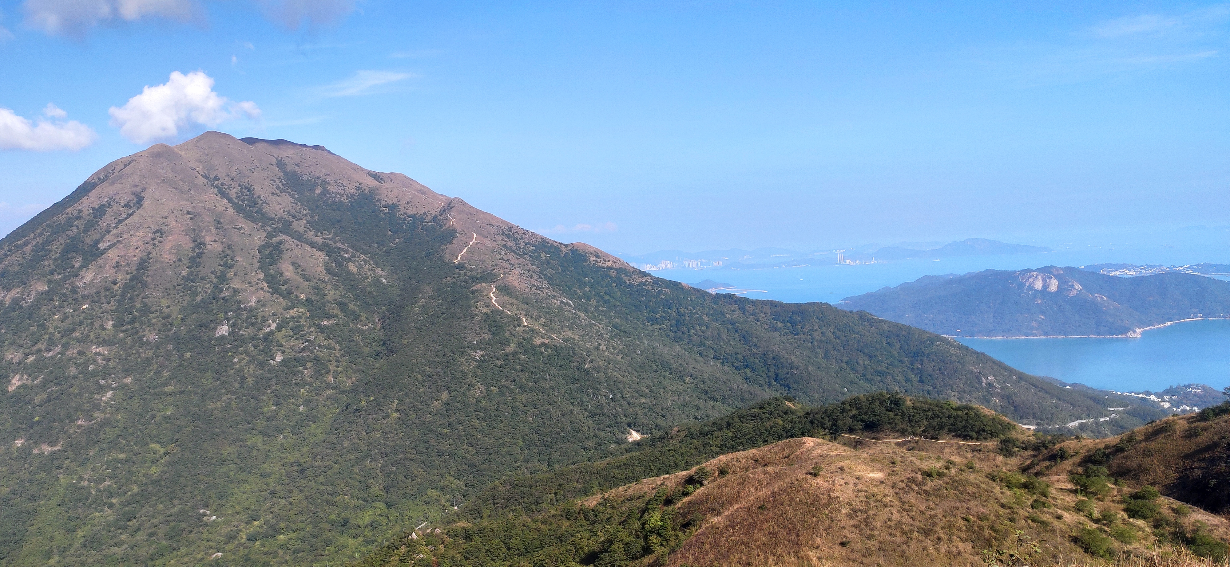
I could hardly believe the beauty of Lantau island. Rocky sea cliffs were surmounted by lush wind swept pine forests, and beyond rose Sunset Peak.

We were headed toward what appeared to be an uninhabited peninsula where there was no place to land. We skirted the coast until we came to a crescent beach with the remains of a derelict concrete dock. This was Tai Long Wan (Big Wave Bay).
The old man shoved me out of his sampan and angrily departed, never to return. I was stranded!
The old man shoved me out of his sampan and angrily departed, never to return. I was stranded!
The beach was beautiful, white granitic sand with tall sand dunes. Other than the derelict dock there was no sign of human habitation. I wandered the beach wondering how I would ever get back when I noticed a small weather beaten sign hanging from one nail. The only discernable word was “Toad”.
A small trail lead through the sand dunes then opened into a magnificent panorama. A little concrete path led through rice paddies being plowed by lumbering water buffalo followed by barefooted men in conical straw hats. In the distance the ancient Chinese village of Tai Long was framed by the dark green slopes of a picturesque mountain. It was like a Chinese scroll painting come to life.

As I stood there admiring the beauty of the scene I was astonished to hear the strains of Johnny B. Good by Chuck Berry coming from the ancient village. It was the first rock and roll I had heard since arriving in Hong Kong. I followed the sound until I arrived at the Frog and Toad which was located in an old Chinese building. The proprietor emerged from the back and said, “Hello! I’m Li Yiu-ming but my friends call me Tequila Joe. Can I get you a beer?”
The delicious smell of barbecued ribs was overwhelming. Without being asked he produced a platter of ribs that would have shamed any Texican. The pig must have weighed 600 pounds! I had found my home away from home!
I looked around as I swilled beer and stuffed my greasy face with ribs. The walls were covered with photos of beautiful nearly naked young English women wallowing in buffalo dung. There were hundreds of such photos, albums full! I had previously found British expat women to be reserved and aloof, but here they were naked with their tits covered in shit! Joe explained that it was a tradition. It happens all the time at the Frog and Toad. One thing was certain, the Chinese never participate in such madness.
I was totally smitten and drunk as as skunk when Joe asked, “Where are the other people from your yacht?” I explained that I didn’t have a yacht. “Then how are you going to get back to Hong Kong?” I didn’t have a plan and would have been glad to stay at the Frog and Toad forever.
“But we don’t have a hotel in the village. What will you do? There is a path across the mountain but it is long and difficult. You would arrive at Silver Mine Bay after the last ferry has left, but you might be able to make it if you hurry!”
I was in no hurry, but I was in good shape, so I slugged another beer, finished the last of my ribs, and asked for directions. Joe explained that when I got to a trail intersection at the high pass I should continue straight ahead then down to the concentration camp visible below. From there follow the coast left to the road to Silver Mine Bay, then turn right. With luck the ferry for Hong Kong won’t have left yet. You better hurry!
The narrow concrete path led steeply upward through fruit orchards, then lush forests of pine and bamboo. It followed the course of a crystalline stream. I had never before seen such a beautiful little concrete path! I later learned that these pixie paths had been constructed a generation ago for the benefit of expat Brits on excursions. The Chinese would never have bothered for they were accustomed to wading through buffalo dung. I huffed ahead as fast as my legs would carry me.
From the pass I looked down at the high chain link walls of a concentration camp built to house Vietnamese refugees. Hong Kong island could be seen in the distance. It was especially cruel that these innocent people, whose only crime was to flee communism, could see but never reach the glittering city of Hong Kong. As I passed whole families politely acknowledged me. It was heartbreaking.
I raced along the coast in the twilight. Just before reaching the road I came across a fine big Chinese cobra sprawled across the path. Ferry be damned. It was my first cobra and I just had to tweak it’s tail! It was nip and tuck as one might say. The cobra was fierce and tried it’s best to kill me, but I finally managed a tweak!

The moment I got to the road a taxi came by. It was a miracle! I encouraged him to go go go for an extra tip. He screeched to a halt at the ferry slip. I threw him a wad of cash and made a mighty leap onto the departing ferry. I had made it! Thus ended one of the best days of my life!
For the duration of my time in Hong Kong I returned to the Frog and Toad as often as possible, sometimes by hiking across the mountain, and one time on a millionaire’s luxury faux junk that came complete with hot sex with a secretary! Once I swam to a different luxury junk anchored offshore and climbed aboard uninvited for a gin and tonic. The Brits never blinked. Another time I rescued a young woman who had torn off her blouse and thrown herself into the sea after proclaiming, “Farewell cruel world!”
Most memorable was my discovery of an ancient abandoned village further along the coast.

The village appeared to have been abandoned very suddenly. The inhabitants had simply vanished and left everything behind. Strangler figs had devoured the buildings. I rooted through the leaf litter beneath the collapsed roofs and found a stash of exquisite porcelain bowls that grace my mantle to this day. The Frog and Toad remains my all time favorite pub, but all good things must pass.
The Frog and Toad remains my all time favorite pub, but all good things must pass.
……………………………………………………………
My expeditions to the Frog and Toad whetted my appetite for the natural beauty of Hong Kong so I wandered the nearby New Territories, those parts of Hong Kong that were attached to the Chinese mainland.

The countryside was magnificent and almost completely devoid of people. I could take the subway to what amounted to the wilderness. There were small mountains with well worn trails that passed through rhododendron heath and golden grasslands. Other footpaths led to ancient villages along the coast that had been abandoned when the inhabitants moved to the enormous human hives that I had seen on the architect’s walls.
From every promontory there were distant vistas of mountains, islands, and sea fading into the mist. China was out there somewhere, unknown and forbidden.
One day I was delighted to find an exquisite small green viper (Trimeresurus albolabris). This is the same species that so terrorized American soldiers in Vietnam that they referred to it as a “two stepper”. I found mine on the ground, but normally they spend the day in low bushes at eye level where they are nearly invisible so I think they should be called “Nose Nippers”. The idea that you will fall over dead after two steps is a myth. They are venomous but rarely deadly.

I once had a Nose Nipper for a pet. It lived in an aquarium on my desk with a screened lid. At that time I had the misfortune to live with a mime who dressed as a jester in filthy green felt and wore curly toed shoes and a dunce cap. Everyone hates a mime and I hated him. He had an obnoxious cat that insisted on sleeping atop the aquarium. I warned the mime to control his cat; needless to say he did not reply but rather grimaced and flipped me the bird.
One day the inevitable happened and the cat was bitten in the belly. It disappeared. Two days later I discovered the cat in the pantry atop the water heater. It had swollen to twice its normal size but was still alive. There was nothing to do. The following day I opened the pantry door to discover that the cat had exploded. There was a fist sized hole in its side through which I could see its internal organs palpitating. The damned thing lived, proof that cats have nine lives and that “two steppers” aren’t really so deadly.
There were plenty of other snakes in Hong Kong, some of which really were deadly. There were other more dangerous vipers, kraits, cobras, and even king cobras. It turned out that there was a simple but most unfortunate way to find them.
Hong Kong has no rivers, lakes, or usable aquifers. It is a very rainy place but all the water just runs down the steep granite slopes into the sea. The British overlords came up with a solution. They built a vast system of catchwaters to encircle the entire island. These consisted of deep concrete ditches to intercept the rain water which was then was shunted through tunnels to reservoirs.
It was long ago discovered that these ditches were inadvertent snake traps. While crawling about they would fall in and be unable to escape. The only shelter they could find were in the tunnels. There, snake catchers harvested them by the hundreds of thousands which left none for me.

The sorry snakes thus collected were destined to be either eaten or used for traditional Chinese “medicine”. Some were sold at “wet markets” where shoppers can browse the latest zoonotic diseases like Covid, Monkey pox, Nipah virus, Ebola, and SARS. Who knows what is next?
Other snakes were taken directly to dedicated snake shops where they were comingled to insure the spread of disease, then kept alive in horrible conditions while being dismantled body part by body part.

The fellow you see above free handled deadly kraits and cobras with apparent impunity. That was because kraits only bite at night, and the cobras were too weak and disease ridden to fight back. The filthy cages were pestholes where otherwise rare pathogens were concentrated and transmitted to the unfortunate inhabitants, which were then disseminated around the world.
I watched in amazement as a Yuppie Chinese businessman in a fancy suit walked in on his lunch break. He needed a “pick me upper”, so the fellow seen above pulled out a large cobra, then ran his hand down the body to locate the gall bladder. Once located he made a small slit in its side, popped out the gall bladder, then squeezed the bile into a shot glass. The bile was mixed with grain alcohol, a cure all if ever there was one. The snake was returned to its cage and the young businessman slugged down the wretched cocktail with relish. The whole transaction took only a few minutes. Does anything taste worse than snake bile mixed with bad moonshine?
It wasn’t just kraits and cobras that were being tortured. Harmless snakes like the flower snake Elaphe moellendorffi were comingled with the rest. A healthy specimen was worth at least $1500, but these weren’t healthy, and the market in captive born neonates had yet to be developed.

As an ophidiophile (snake lover) I was horrified to see such rare and beautiful animals being slowly tortured to death. That weakness led me to do one of the stupidest things I have ever done. At the time I knew that reptiles were susceptible to many diseases within their native range, but I had failed to grasp the epidemiological consequences of the international trade in wildlife.
The snakes were cheap, so I bought half a dozen moellendorffis and a number of other species including a radiated rat snake Coelognathus radiatus. Radiated rat snakes are one of the meanest snakes on earth. They will literally stand on their tail while trying to bite you in the face. The fact that it was docile should have told me something was wrong, but I was on a crusade.
I carefully boxed them up and took them to a shipper who charged me a fortune to air freight them to a friend’s house in Gainesville. My friend had no idea they were coming. Surprise! He was delighted at first, but then they started to die.
I can only hope that he didn’t release the dying snakes, but even if he didn’t, other herp hobbyists have. The exotic reptile diseases thus spread have destroyed herpetofauna throughout the world. Here in Gainesville Florida, a place where Archie Carr once recorded one of the greatest number of snakes anywhere on earth, there are no more snakes.
I carry a great burden of guilt for such actions. I thoughtlessly destroyed that which I love. Now it is too late to do anything about it but to remember back to when the world was still alive, and weep.
………………………………………………………………….
One day I decided to poke around in a dark catchwater tunnel with a headlamp. There were no snakes, but I did discover a very strange creature. It appeared to be an Opilionid harvestman (called a daddy longlegs in the US), but it featured a prominent spike in the center of its cephalothorax. It looked like a little monster from another planet. I later learned it was a species of Gagrella.

Because of a shared interest in herps I had met a prominent professor whose name I have forgotten. Every year he brought students from the US to study the natural history of Hong Kong. One of those students was a budding young entomologist who was attractive enough to draw the attention of a horndog such as myself. I figured the little monster would do the trick, but when I proudly presented it to her she recoiled in disgust and said, “Ewww! What kind of terrible bug is that?” My ardor was dampened. Next!
One day I was exploring the north side of beautiful Lantau Island and flipped a rock in a small stream to discover a small eel like creature that I thought might be a Caecilian, one of the world’s strangest amphibians.

I was really excited because Caecilians had never been reported in Hong Kong. I carefully replaced the rock and rushed to tell the professor. He was excited too, and asked where I had found it. I gave him a detailed description of the location and of the rock. Later, he follow my instructions and found the same creature under the same rock. He was astounded that I could give such precise directions. It turned out to be a swamp eel Monopterus albus, but the professor was nevertheless impressed!
I was fortunate to have arrived in Hong Kong in spring to witness the blooming of the Rhododendron heaths in the New Territories and Lantau Island.

I never saw any Rhododendron heaths quite as spectacular as the ones in Vietnam, but almost!
I was especially smitten by Rhodoleia, a shrub in the Witch hazel family which somewhat resembles a Camellia. I have a beautiful specimen in my yard to this day!

A little later in the season my walks were graced with abundant Melastomes, one of the prettiest weeds imaginable!

The urban landscapes were interesting too. Despite the bustle and grime of the city wild nature persisted in the cracks. Any hard surface not directly impacted by tires or feet was likely to be overgrown by the roots of strangler figs. This was especially true of revered ancient shrines.

…………………………………………………….
At the beginning of this essay I referenced the herd mentality of the Chinese which is so different from our individualistic western perspective. One day I decided to hike to the summit of Sunset Peak on Lantau island. I had no idea that it was a traditional Chinese holiday during which picknickers visited the countryside.

My first clue as to what was going on was the fact that I couldn’t get a taxi, so I walked to the ferry terminal. There, I discovered a crowd of thousands of young people with backpacks all trying to board the ferry. The ferries in Hong Kong are huge and can carry many hundreds of people at a time. As soon as one ferry departed another showed up. I asked what was going on, and the answer was “Holiday!”
The phenotype of the Hong Kong youth had changed greatly from that of their rugged forebearers. Rural peasants and the sorority of old hags on the waterfront may have been tough as nails, but these young people were pallid, plump, and weak.
We were discharged at Silver Mine Bay. The exodus resembled the migration of wildebeest across the Serengeti. Thousands upon thousands wearing flip flops, knickers, colorful blouses, and little backpacks marched up the road toward the trailhead. A taxi was out of the question, but the busses ran nonstop.
At the trailhead they surged up the slope like locusts heading for greener pastures. I despaired of ever reaching the peak, for the narrow trail was totally clogged with people, but after walking a short distance uphill the groups of people spread out all over the countryside, lay down their blankets, and began to picnic.
The groups remained separate from one another, and around each group was an ever growing ring of trash. To my astonishment none of them appeared to be headed for the peak. They had come all this way just to go a few hundred meters into the countryside to picnic. It was all about exclusive groups, and had nothing to do with an appreciation of nature. There were no individual hikers whatsoever. I breezed past them all and headed up the mountain. Not a single one of the thousands of young people joined me.
Sunset peak is almost 3000 feet tall, so it was a challenging ascent from sea level where it was hot and sunny to the cloud covered summit. The trail went from a well trodden path to a series of steep stone steps where the way forward was often obscured by sodden grass and drifting mist. A cold wind howled and rain threatened. I was careful to mark my steps, for it would have been a most unpleasant place to spend the night.
As I stood there shivering on the peak I noticed a furtive figure wandering aimlessly in the mist. I hailed him under the pretext of asking if there was a better way down the mountain, but as he approached I could see that he was disoriented. His eyes were glassy and his footsteps uncertain. He was wearing light polyester clothing, was shod in slippers, and carried a branded shopping bag from a mall.
His first words were, “Where is the store? Where is the shopping mall?” I told him that he was on Sunset peak, but he continued to insist that he was at a shopping mall. It was clear that he was demented and in danger, so I took him by the elbow and firmly guided him back to the steep stone steps. I said, “You must promise me that you will not leave this path. It is the only way to the shopping mall.” I took my own advice and headed down by a different path.
In all my wanderings around Hong Kong and mainland China over a two year period I never once saw another solitary hiker, just one madman intent upon shopping.
………………………………………………
Back at the Kuok Brothers office the plans from Belt Collins had finally come in. As I expected, the design was terrible. They had been asked to create a naturalistic pool, but it looked like a cheap version of Disneyland plunked onto a concrete slab. Needless to say, the rocks had to be fake, there was little landscape, and nothing to disguise the fact that the pool was on a slab perched over the ocean..
I headed to a restaurant in despair to wash my sorrows away with beer. There was no way I could build the ridiculous design proposed by Belt Collins, so I asked for a pile of napkins and started scribbling alternative designs. The next morning I took my napkin to Ean Kuok. He agreed that it was a better concept, but the wheels grind slowly, so it was time to continue waiting.
I was curious about mainland China, but assumed the communist fanatics would not allow me to enter the “People’s Republic”, or that if I did I would have to be on a guided “tour” and not be allowed to wander freely. A Chinese friend assured me that was not the case. A visa could be easily had, and once there I could do as I pleased. He actually got the visa for me! He also created a little book with useful phrases in English, Mandarin, and pinyin such as, “I am here to look for snakes. Where do they live?” and “How much is a beer?”
I decided to visit the tourist town of Guilin. If you have ever been to a Chinese restaurant in the USA you have seen pictures of Guilin and the Li River on the walls. It is considered to be one of the most beautiful and iconic landscapes on earth, a place where bizarre karst towers rise from a verdant landscape in the heart of ancient China.
I was only planning to be gone for a few days, so I took nothing with me but a day pack and a spare tee shirt, then jumped on a plane for the short flight. I had no idea of the extraordinary adventures that awaited.
Stay tuned for the next installment as the Weazel plunges into the underbelly of a vast civilization lost in time!

