
When last seen in Peru the Weazel and Dr. Ann were acclimating to altitude in the historic city of Cajamarca. Our attempt at fitness was a failure, for we were both suffering from a chronic low grade respiratory infection brought from home, yet another such gift from the White man to the Indian. Our work done, we continued our journey to the east.
To reach our destination, the remote city of Chachapoyas, we had to pass through the pleasant little town of Celendin before plummeting into the abyss of the Marañón river, then up again into the clouds.
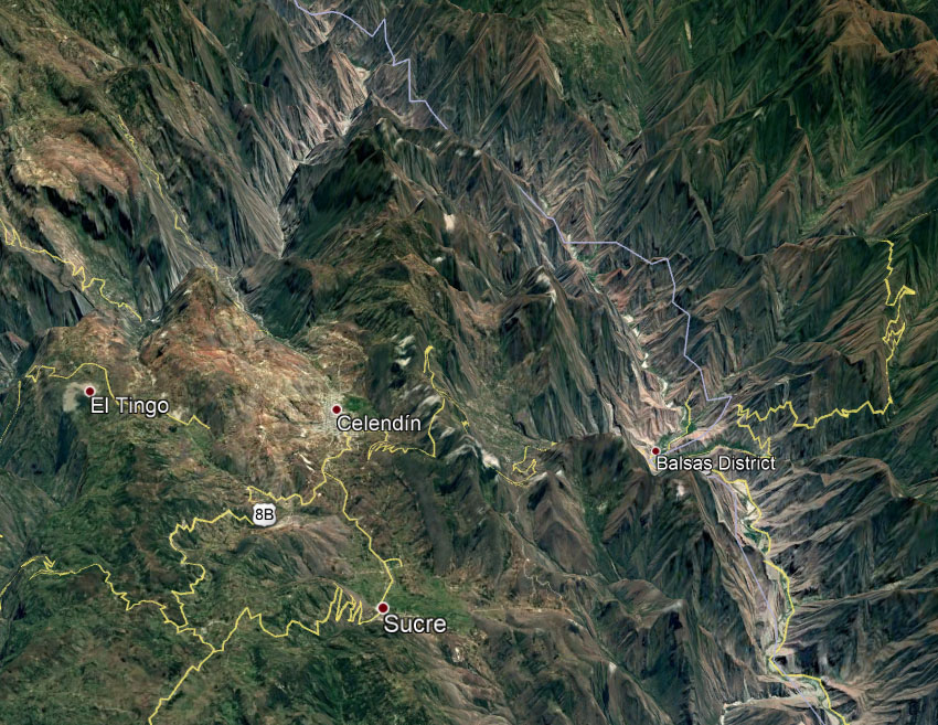
The pass just east of Celendin is 10,215 feet in altitude; whereas, the Marañón at Balsas is 7450 feet lower at only 2765 feet. From Balsas the road ascends another 8995 feet to Black mud pass at 11,760 feet. The total elevational change of 16,445 feet in only 18 linear miles (65 miles by road), makes the Marañón one of the deepest steepest canyons on earth. The section seen here is more than 2000 feet deeper than the Grand Canyon. For this reason and others the tiny road to Chachapoyas is considered to be one of the most dangerous bus trips any foolhardy traveler might wish to undertake.
The road from Cajamarca to Celendin was pleasant enough, it passes through a fertile agricultural plateau with occasional small villages.

Celendin proved to be a delightful little place rarely visited by tourists. We knew it was a relatively prosperous town because the street dogs were all deformed Pomeranians rather than the usual mangy mutts. We checked into a swank hotel with plush velvet couches that cost only $7.50 per person, then tucked into a plate of stewed cuy.

Later that evening I wandered the empty streets in search of a libation. All was quiet until I saw a “Lounge” sign in a doorway and heard the sound of music coming from an upstairs window.
I had expected a cantina but it was indeed a lounge. The living room of a nice middle class family’s home had been transformed by couches and a bar into a gathering place for local intellectuals. The patrons included a dwarf karaoke singer who lamented that the world wasn’t ready for his poetry.
Back at the hotel I met a tough looking pair of motorcyclists, a Kiwi and a Gringo. I could tell they had just come from Chachapoyas by their white knuckles and shell shocked eyes. They told me the road was utterly terrifying.
In the morning we set out in search of a bus that would take us to hell if not back. Everyone assured us that the Virgin del Carmen line was the best because it was under the personal protection of the Virgin, and the busses were small enough to fit around the turns.
We were not reassured when the family in line ahead of us began to cry and pray. The father explained to the ticket lady that it would be a tragedy if his wife and children were to die, so “What are the chances?” She smiled a tired smile, pointed to a statue of the Virgin, then said, “Almost everyone survives the ride”. What more could you ask?
I was greatly concerned that my innate acrophobia combined with motion sickness would make the ride a living hell, but the road was so narrow that I couldn’t even see the dropoff from my window seat so I couldn’t tell how close we were to the edge. I just kept my eyes on the horizon and all was fine.
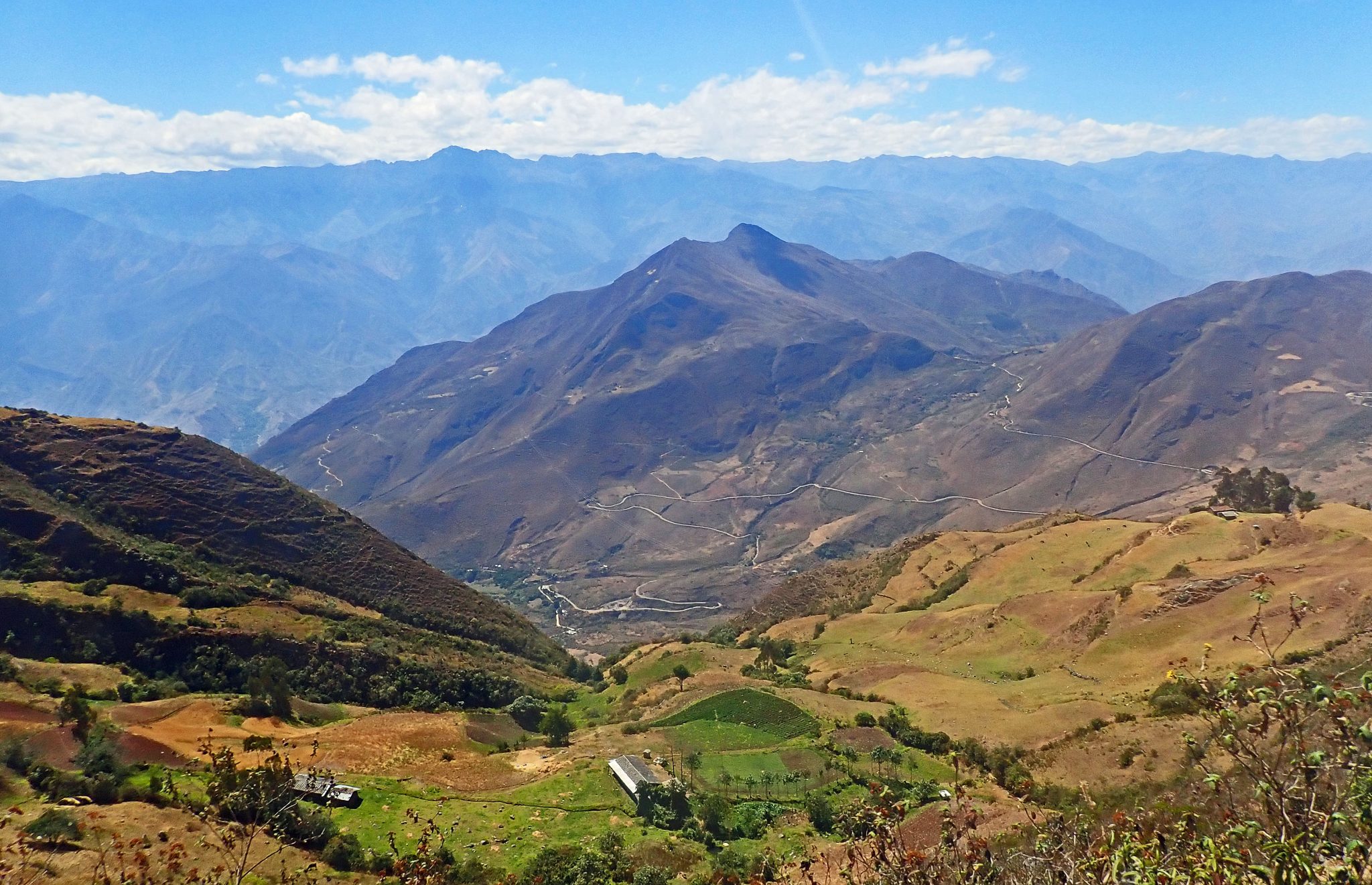
Notice how little the road looks far below. This is the only road that crosses the Marañón for more than 80 miles in either direction. I was very pleased to discover that though narrrow it was recently paved. We only had one near head on collision with a dump truck.
As we descended the gorge we entered an uninhabited desert region with vegetation more typical of the lowland dry tropics. We might as well have been in Mexico.

The mighty Marañón was still far below us.
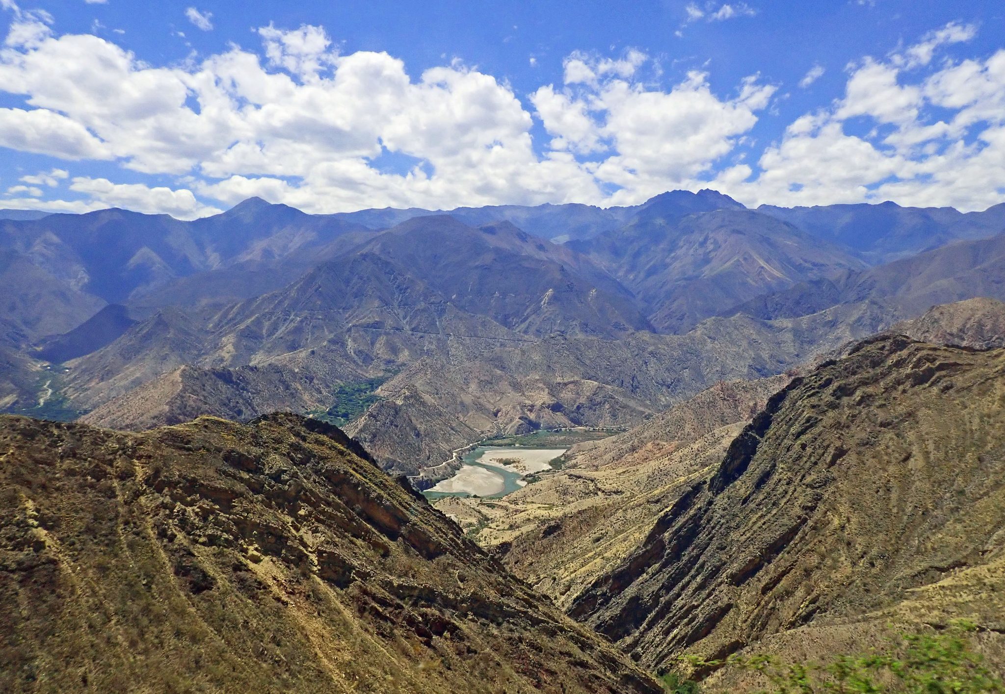
It is not hyperbole to speak of the “mighty” Marañón, for it is a river of superlatives once thought to be the source of the Amazon. Though more distant sources have been discovered, it flows for over 1000 miles, and remains by far the largest tributary to the world’s greatest river. In places it is nearly twice as deep as the Grand Canyon.

Here you see the bridge at the tiny town of Balsas, known locally as “Infierno” (Hell) because, despite being 2765 feet above sea level, it is the hottest place in all of Peru. It is worthy of note that the word Marañón means cashew in Spanish, but the town of Balsas has no cashews, instead, as you can see, the few huts have nearly disappeared beneath a canopy of mango trees, many of which were groaning with fruit.
The bus stopped briefly to pick up a few sacks of mangos, then we began the endless ascent.

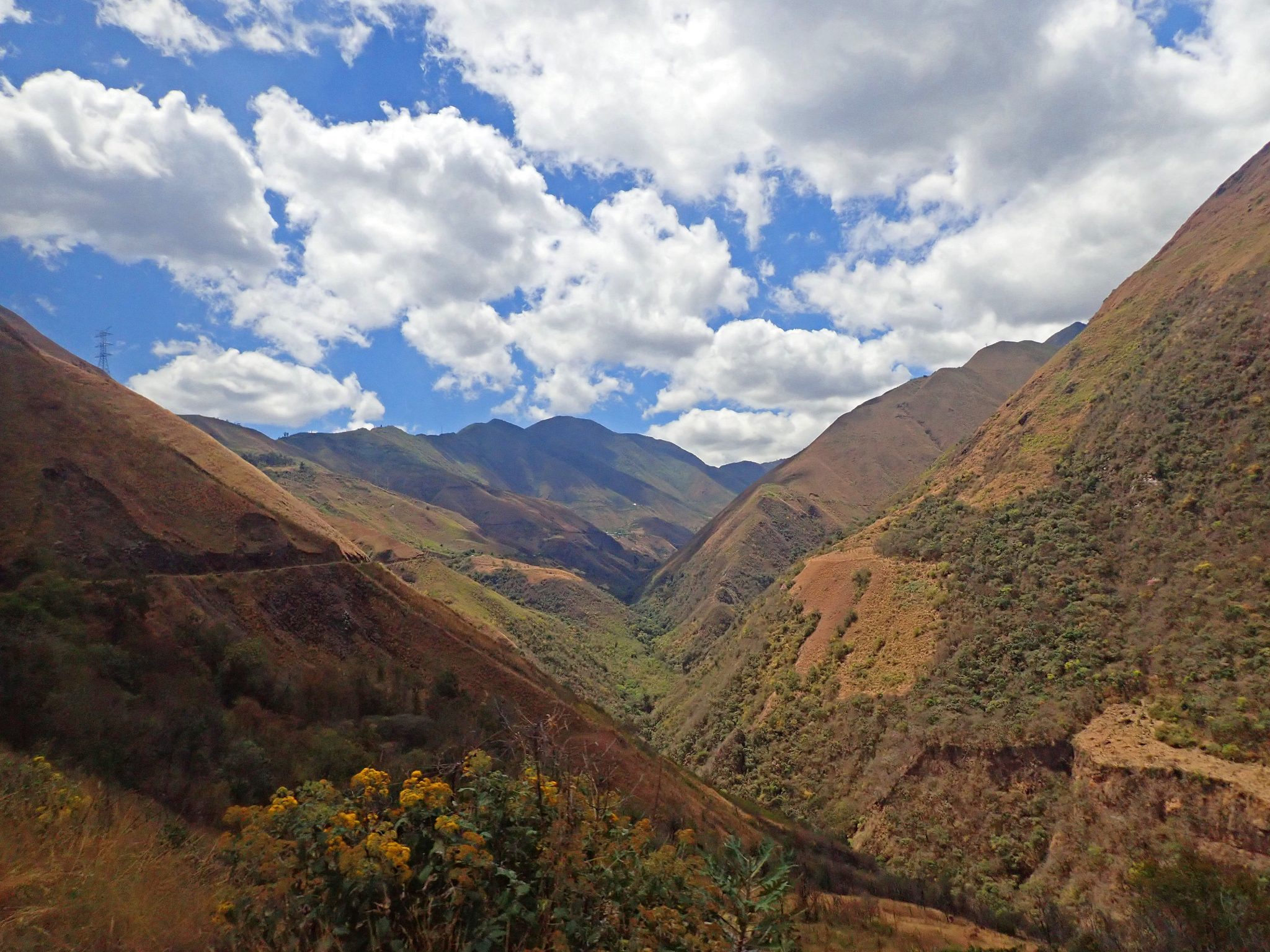
Note the constriction in the road where it becomes barely one lane wide due to a previous avalanche. Every day there are avalanches which often obliterate the road entirely. When that happens, presuming you haven’t been swept away, all you can do is wait, perhaps a week, for heavy equipment to arrive. Thirsty yet? This was the stretch where we almost had a head on collision with a dump truck that was barreling down the mountain and screeched to a halt only twenty feet in front of us.
Here is a typical example of a more recent avalanche. Notice that the edge of the recently repaired road is actually hanging over the abyss.

After ascending another six thousand feet or so we entered a more habitable climatic zone where tiny homesteads were tucked into side valleys.
At this elevation we had left the desert far behind and had entered a zone of extensive rich grasslands with forested valleys. It looked superb for grazing, yet we saw no livestock whatsoever, not even a llama, and people were few and far between. Something must be eating the grass, but what? I would imagine that in the absence of grazers the ecosystem would be dominated by rodents such as the rabbit like viscacha, but not a creature was stirring, not even a mouse.
As we approached Black mud pass at nearly 12,000 feet we saw our first example of the 25,000 mile long Inca highway system that tied the empire together, and enabled runners to inform the Sun King of distant events only days after they happened. How else to get fresh seafood to Atahualpa’s table in the thin air of Cuzco? The Inca highway system rivaled that of ancient Rome, and is still in use today by those with strong legs!

After crossing the pass down we went into the lush Utcubamba river valley where we found the exquisite little town of Leimebamba It was the first warm, moist, green place we had seen in Peru.
Leimebamba is best known for its mummies, hundreds of which have been collected from area caves and crevices and are now on display in a museum. Thousands of others have been stolen by looters. These mummies were not the work of the Inca, but rather of the Chachapoyas culture that long preceded them.
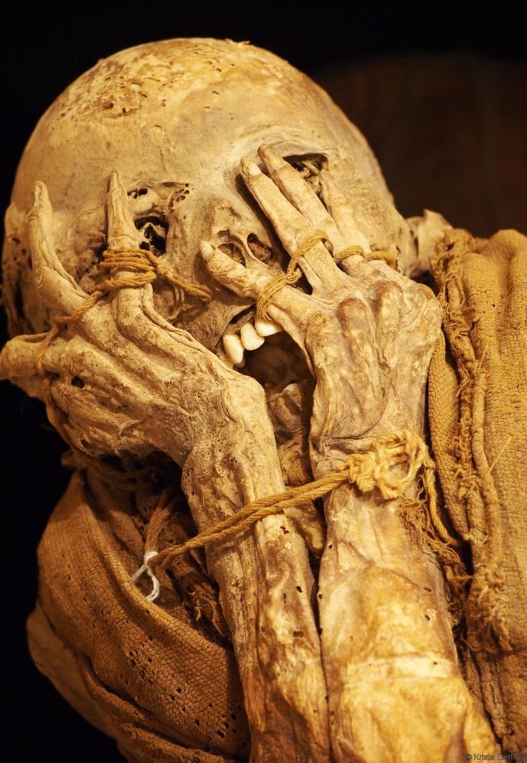
Most of the mummies came from the magnificent Laguna de los Condores (Lake of the Condors) which we hoped to visit but that required an arduous trek or journey by horseback. I am sorry to say that we never made it.

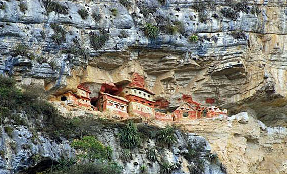
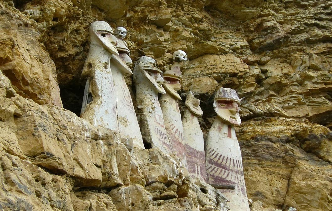
The entire valley of the Utcubamba is filled with the ruins of the Chachapoyas people whose civilization flourished long before the Inca, and about whom little is known. They were known for their elaborate funerary practices, not just mummies in caves, but also cliffside mausolea such as Revash…
and the sarcophagi of Carajia.
The most famous Chachapoyan ruin is the mountaintop fortress of Kuélap, said to be the “other Machu Picchu”, but that is nonsense for there is little resemblance. We will visit Kuélap in a future post.
There are numerous other ruins in the area that remain unexcavated, and there is a great probability of the discovery of entire cities that remain lost in the mists. As you will see, we even discovered two of our own!
We had every intention of returning to the quaint little village of Leimebamba to see these and other wonders, but it was not to be.
After an exhausting twelve hour ride we arrived in Chachapoyas where adventure awaits, so stay tuned!
