
After a delightful but chilly sojourn in northwestern Georgia the Weazel and Dr. Ann broke camp then headed to nearby Tennessee to join friends high atop Jumpoff mountain, a bucolic locale not far from the scenic little town of Sewanee, home to the beautiful University of the South.
Caver’s paradise is a private campground owned by an extraordinarily resourceful woman named Maureen who welcomes all those who are dark of experience (as in those who are cavers!) yet are light of spirit. She asks only a pittance, and that campers show a willingness to help out with mundane tasks like feeding firewood into the sauna, collecting fresh road kill for dinner, and occasionally making superhuman efforts to clean up rural Tennessee.
So it is that an everchanging cast of oddballs, intellectuals, hillbillies and scientists converge from around the world to sit around the fire. The only thing these people have in common is a desire to crawl into a hole in the ground. I used to have that desire, but now I’m happy just to walk around.
Jumpoff mountain is such a holey land for cavers that all a visitor needs to do is to walk in any direction. In short order you will reach the edge of the Cumberland plateau and a cliff. Find your way around the cliff if you can. About halfway down the mountain the numerous small streams that fall off the plateau disappear underground. That is where the trouble starts.
There are more than 10,000 known caves in Tennessee, but the ones near Caver’s paradise are not the friendly caverns with lighting and handrails that you visited with your parents as a kid. “Look Dad, that stalagmite looks just like my wangdoodle!” Instead, most are extremely dangerous multi drop pits with names like Hang ’em high and Snake well.
These usually begin with water pouring into a tiny crack of apparently bottomless depth. Our hero throws down a rope (with a knot on the end!), clips in, and descends. Despite efforts to avoid the waterfall the ice water invariably runs down the back of your neck. Meanwhile, if extreme caution is not exercised rotten rocks will peel off the sides of the ever expanding shaft to thunder into the abyss. If you clip in wrong, or if it rains outside and the waterfall becomes too strong, or if you happen to be in the way of the rock, your trip is over.
As soon as you land in a pile of unstable talus it will be necessary to do a scary traverse to the next rig spot where you will throw down another rope and repeat the steps above. There may be many such drops in a multidrop pit until you can go no further. Then it is time to return the way you came. I hate that!
Very few of these multidrop pits make it to the bottom of the mountain. Those that do may begin as a nasty little crack with a trickle of water, but further down they become roaring river passages with sumps where you get to hold your breath and hope.
One evening I was sitting around the fire when a crew returned from a pull down trip to Solution rift in Fiery gizzard holler. (A pull down trip = suicide. No one in their right mind pulls down the rope that could be their only hope of survival!)
There was death in their eyes. They had been forced to drag heavy ropes through agonizing crawlways only to meet sump after sump. When they got to the bottom the entrance had been flooded by an angry beaver so it was time for a final sump dive. That was when I decided never to explore Solution rift. I’ve been to the lower entrance and met the beaver. That’s enough! Trembling reader, I’m only telling you this to discourage you. It is a select few who voluntarily engage in such madness, and we like to keep it that way!
………………………………………………
But enough of darkness, this was Blackberry winter, cool crisp late springtime weather when it should have been sweltering, so it was time for some sunny fun!
Upon arriving at Maureen’s we set up camp in the woods and built a much needed fire. As I sat there I was dismayed to see a pack of dogs approaching. I hate damned dogs! They surrounded me, but instead of growling and biting they attacked me with licks and kisses and would not be deterred. From beneath the dog pile I realized that our dear friends Anne and Blaine were out for a walk and had collected every friendly dog in the neighborhood along the way. It is a fact that nice people have nice dogs, and the inverse is even more true.
We made plans for adventures to come, then Ann fixed a delicious salmon broccoli dinner. What could possibly be finer than a visit with old friends, a bottle of wine and a slab of salmon around a roaring fire, then to crawl into a warm sleeping bag with one’s beloved?
In the morning I chanced upon an interesting itinerant named Wolfie who lived in one of the tiny A frames that Maureen rents to those who prefer not to repose upon the ground. He explained that Maureen, who was busy in Chattanooga, had recently purchased additional land so that Caver’s paradise would be contiguous with the nearby State forest. He offered us a tour, so we limbered up with an easy stroll of a few miles, then headed to Sewanee for lunch.
The choice of venues was easy, for Sewanee has only one restaurant, a funky little hippie establishment named Shenanigan’s. The town has one very busy convenience store that sells nothing but beer, no gas station, and nothing else other than the extraordinarily beautiful campus of the University of the South.

The University of the South is more like a refuge than an actual university. It is a magnificent stone citadel set in an ancient forest surrounded by cliffs, a romantic dream that elsewhere is “Gone with the Wind”, but still lives on in the land of lethe.
The students drift about unaware of affairs in the outside world. They are required to live on campus, attend chapel, and wear ties, but there are no rules against shorts and flip flops. Equestrian study is the primary curriculum. It is the perfect place for a nice young lady in crinoline to meet the fine young heir to a Kentucky stud farm. There must surely be a black person there somewhere, but I have never seen one. If you would prefer to live in urban squalor, study Critical Race Theory, and participate in riots, then perhaps you should apply to Berkeley instead.
The Domain, as it is called, is 13,000 acres in extent yet has only about 2000 students. It features 65 miles of hiking and horse trails! We were eager to visit some of the more remote trails, but to our dismay we discovered that parking had been banned almost everywhere on campus. No problem for someone with a handy horse, or perhaps a mountain bike, but too far for us to walk on our old aching feet, so we parked by the side of the road and snuck in to hike the Piney point trail.

The Piney point trail features the usual dripping cliffs, burbling brooks, waterfalls, and beautiful overlooks.

“lookey thar Josie, see that puff of smoke down in the valley? Thems could be the damned Yankees. We’d best set up our cannons over across Shake rag holler on Green’s view point!”
Note: As a matter of fact, they did shake a rag at the Yankees, a white one. The Domain gave up without a fight!
I gave up too. I was so tired from days of hiking on flatlander legs that I collapsed on the rock where the above photo was taken and couldn’t get up! I was afraid that if I stood up I would fall over the edge so I crawled away in ignominious defeat!
It was time for a day of rest, but the following day was too warm and sunny to resist, so Anne took Dr. Ann and I on a rim ramble along an obscure trail that she had recently discovered.

The walk was so easy and pleasant that after a few miles I suggested that we head directly back off trail. Anne, who knows the area well, thought that was a bad idea but went along with it anyway, more sporting if nothing else.
The edge of the plateau had been protected, but as soon as we entered the woods away from the edge the wholesale destruction typical of State forests became evident. The forest had been clear cut and had regrown into a nearly impenetrable thicket. Off road vehicle trails were everywhere, and everywhere they crossed a stream there was terrible erosion. After thrashing through the bushes we arrived at a party spot at the end of a dirt road. It looked like a war zone.

If you look closely you will see that the ground is literally covered with bullets and shotgun shells, thousands upon thousands of them! The beer cans, bottles, and other rubbish had been blasted back into the bushes where it mounded up in heaps.
Many of my yuppie enviro friends think that nature should be pristine, and that all of our public lands should be set aside for bird watching. That’s nice, but reality doesn’t work that way.
People who don’t share “our” values also like to play in the woods, and for them it is all about guns and motorized vehicles, freedom of the most primitive sort. Yee haw! And let’s not forget that, “Y’all ain’t from around here, so don’t tell us how to live!”
As much as I may not like it, I think it is critically important that efforts to protect nature have the broadest possible constituency. Guns, hunting, garbage, and ATVs may be obnoxious, but the real problem is clear cutting, a nationwide tragedy driven by economic forces that rarely benefit the local people to any real degree. If we can’t find common cause with Bubba then the Cumberland plateau will wind up looking like Ethiopia and the wars will never end.
That evening back at Blaine’s man cave/brewery he plied me with enough of his superb mead that I recovered my strength and was ready to fight the damned Yankees (or the pulpwood loggers) yet again!
The following morning the weather was so nice that I decided to drive to Alabama to look for rattlesnakes. The spot I intended to hunt wasn’t far away, only 18 miles as the crow flies, but going anywhere in such complex terrain is a challenge. The only possible route required driving north to Sewanee, down the mountain to Cowan, west to Winchester, south most of the way to Huntsville Alabama, then north up the Paint rock river valley, a minimum 50 mile one way trip.
While we were passing through the run down town of Cowan I decided to look carefully at the map to see if any shortcut was possible. That was when I noticed the tiny word “tunnel” distant from any road but only a few miles from town. It wasn’t clear how to get there, but wherever there is a tunnel there must be a railroad. Railroads invariably pass through the centers of old southern towns, so that part was easy. So it was that I abandoned the rattlesnake hunt and went in search of the tunnel.
There was no real road alongside the tracks, and plenty of no trespassing signs, but it was obvious that locals on ATVs considered the railroad right of way to be a thoroughfare, so we drove along the tracks as far as seemed prudent then parked at a wide spot. Immediately next to us was a towering ruin.

From our vantage point at the foot of this monstrosity it appeared that we had discovered a post apocalyptic Manhattan.

Apparently the Joker was not content to leave Trump towers embowered in poison ivy, for there were hidden pitfall traps everywhere, and concrete tanks of unknown depth filled with vile liquid. These were obscured by vegetation, or in some cases by rotten planks, all of which made exploration extremely hazardous. Dr. Ann, who is very brave, was not happy to be here.
A more distant view gives a bit of perspective.

Like Manhattan, all of these towers were connected underground by a series of dungeon like passages.


Notice the complete lack of graffiti. Not even a beer can! Town isn’t far away, so the only explanation is that local people hold this place in superstitious terror!
But what is it? These were lime processing silos, but how they worked is a mystery to me.
One thinks of a silo as being an overgrown storage bin, but these were not used for storage. If these had been used to store lime or some derivative thereof atmospheric humidity would have congealed it all into a solid mass, but as it was they were completely empty, not even any dust. If they were used for processing where was the inevitable dust?
Through holes in the exterior walls I could see ladders and machinery far above, but there was no way whatsoever to reach any of the upper levels. It embarrasses me to find all of this to be so mystifying. I thought I understood something about lime production, but apparently I don’t.
The one thing I am certain of is that this extraordinary ruin must have been crawling with copperheads and rattlesnakes, but the only way to find one would be to inadvertently step on it!
The tunnel lay somewhere ahead. The railroad right of way was very narrow, and turning around might be difficult, so we grabbed our packs and trudged ahead through the loose gravel. The tracks were still active, and soon a freight train came blasting by heading our way. I found that rather strange since a modern tunnel would surely have a road leading to it.
A look at the topo map deepened the mystery.

Notice that the railroad tracks going east from town appear to diverge at the foot of the mountain, then one track loops over the other to head north toward Sewanee; whereas, the other disappears under the mountain to reappear who knows where?
About a mile from the car we found the bifurcation, but the tracks leading to Sewanee had disappeared altogether. Nothing was left but an otherwise abandoned dirt road used by ATV riders. It began to ascend the mountain, so we climbed back down to the tracks, and there before us lay the entrance to the tunnel.
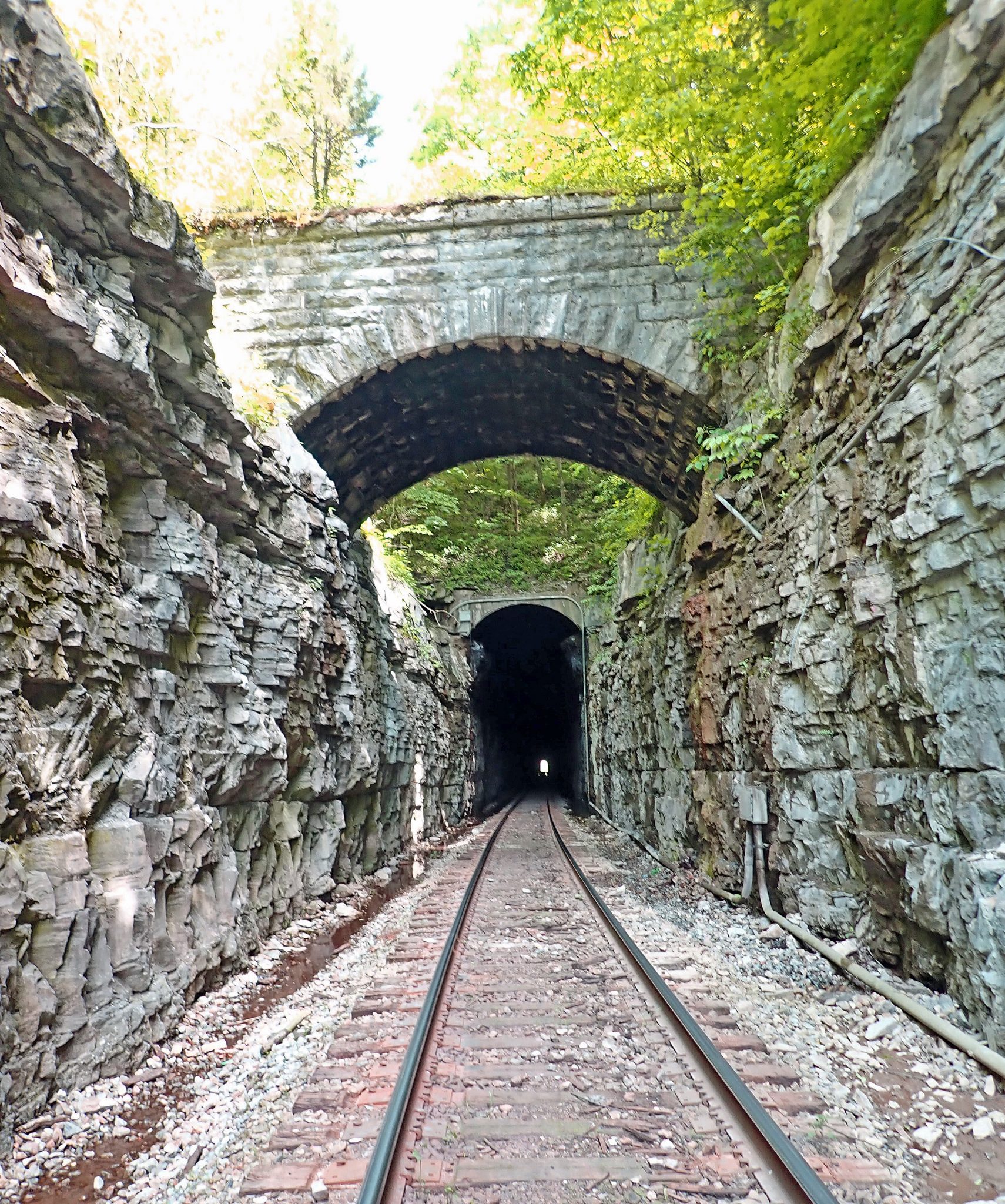
The stone bridge in the foreground once carried the tracks to Sewanee. What an odd configuration for tracks to cross in such a manner. Back in 1853 it must have been a sporting proposition for a steam locomotive to negotiate such a steep and sinuous grade! At the time it was the steepest railroad grade in the entire world. That is why it is known today as the Mountain goat trail.
Here she comes! The Mountain goat express leaning into a turn!

The lower tracks were obviously still active, we had seen a train, but how could a modern train fit through such a narrow tunnel? We could see the proverbial light at the end of the tunnel, but it was difficult to determine how far away it was.
The train had already gone through so we weren’t too worried. We put on our headlamps (cavers always carry headlamps!) and headed in, but once inside the light at the end of the tunnel still seemed far away. We later learned that the tunnel is 2,200 feet long.
Had a train come through there would have been no place to hide other than to lie flat in the water filled ditch on either side of the tracks, hug the wall, and let the train pass over us.

As we trudged along, oblivious to any danger, we discovered several vertical shafts that intersected the tunnel. These appeared to be natural solution tubes about 150 feet deep complete with stalactites, but I suspected that they were actually ventilation shafts.

Moments after exiting the tunnel on the eastern side another train came roaring through from the opposite direction. It was a narrow escape!

Like I said, there was no room. Either lie flat in the crack or die!

While crossing the mountain on our way back, we discovered the upper entrance to one of the ventilation shafts.

There were three such ventilation shafts. All were surrounded by stone walls as though they were water wells.

It must have taken a lot of work to dig half a mile through the mountain with pickaxes and black powder, then to dig three 150 foot deep shafts, then to place useless stone walls around the shafts, but that is why the Good Lord in His wisdom created Irishmen and slaves!
I later learned that the Cowan tunnel was completed in 1852, and was the longest tunnel in North America at that time. It emerges into Crow creek valley, a remote place that is much beloved by cavers and aficionados of strange little inbred communities like Sherwood. Needless to say the Yanks and Rebs fought over it, but the strategic importance was such that neither side blew it up. It is one of the oldest tunnels in the world that is still in operation today.
It had been a great day with many discoveries, but no rattlesnakes were found, so the following morning I headed to Alabama to hunt a place that I will call “Cucaracha cove”.

The cove features little in the way of scenery. What makes it so special is the richness of the ecosystem, for the place verily throbs and buzzes with life!
The Cove is a small part of the wonderful Skyline wildlife management area in northeastern Alabama. The rich bottomlands were once the domain of early settlers, the remains of their log cabins can be found all along the base of the mountain, but by the 1920s the area was effectively depopulated and the farms reverted to meadows.
Today those same meadows are maintained as wildlife food plots. Corn, sesame, and other crops are planted on a rotating basis, all for the benefit of wildlife, especially deer and turkeys, but everything else benefits too.
Hundreds of acres of unharvested corn means zillions of rats and mice. Wherever that happens there will be many predators, especially snakes! Though the weather had been cold, my visit was too late in the season. The vegetation had grown so thick that it was impossible to even see the ground, much less to find a snake; nevertheless, I had a great time looking, for anticipation is everything!
I could not help but to reminisce about a 2010 trip to the cove with my late sculptor friend Thomas Glover White. It was the end of the day and we were crossing a burned field when suddenly Tom did the equivalent of a double backflip. He had almost stepped on an enormous rattlesnake!

It was so big that when he picked it up it bent his snake hook!

I prefer to think that the big nipper is still out there in Cucaracha cove, so if you can figure out where this secret place is you had better step lively!
Back atop Jumpoff mountain we enjoyed diner with a fortunate friend whose beautiful home overlooks Sweden cove far below. We were joined by a family of friendly foxes who made sure there were no leftovers. Back at camp I was sitting around the fire when I was approached by another friendly fox. Cavers make better neighbors than gun toting rednecks, so it seems they are getting tame throughout the neighborhood. The same phenomenon of fox self domestication is happening around the world, even in London. For many species co-evolution with man is the only way forward. If you can’t beat ’em join ’em!
And if you can’t escape ’em, just head to Savage gulf, they’ll never find us there! So the following day we did just that. Savage gulf is located in the middle of Tennessee at the head of the Collins river in the very heart of the Cumberland plateau.
These gulfs, hollers, coves, valleys, or whatever you might wish to call them, are erosional features at the dissected edge of the plateau. That can be easily seen in the terrain view map below. Some say Savage gulf looks like a crow’s foot, but I think it looks like 15,000 acres of magnificent wilderness!

I was too worn out from the previous day’s trek to walk either far or fast, so Dr. Ann went ahead to Savage falls while I dawdled along the trail.
It was interesting to observe forest regeneration after a series of minor natural disasters had befallen the place. It appeared that in this area the plateau had once been dominated by white pines. These had been decimated (to use the word properly for once!) by bark beetles. They had killed some, but not all, of the pines. Bark beetles are a natural pest, but industrial forestry practices have greatly exacerbated the problem. Some years later many of the remaining pines were flattened by a tornado. So it was that the plateau top was strewn with the corpses of giants.
It may have looked bad, but the forest was thriving because the disturbances had not affected the soil organisms, or the seed bank therein.

This Pink lady’s slipper orchid Cypripedium acaule is proof that the soil is alive and well. Orchids require fungal symbionts to survive. In this case the symbiont is a mycorrhizal fungus in the Rhizoctonia group.
If this forest had been clearcut, then been mechanically mutilated in preparation for replanting, the community of soil microorganisms would have been destroyed, and these beautiful orchids would have vanished forever. As it was, the fallen trees simply added a few more nutrients.
I am pleased to learn that not only does Rhizoctonia nurture orchids, but it is also highly pathogenic to lawn grasses and certain other monoculture crops, a double bonus. Go shrooms!
The trail lead across two quaint swinging bridges.

Across the bridge Dr. Ann was waiting patiently on the rocky bank of Savage creek.

We continued down to beautiful Savage falls.

It is said that somewhere below the falls there is a remaining tract of virgin forest. I have tried to reach it several times, but it is too far for my injured feet. I’m just glad to know that it is still there.
After a week of good fellowship and fine adventures we reluctantly bid vaya al Diablo to Maureen and our many friends at Caver’s paradise then headed to Alabama. Stay tuned!

Superbly entertaining, as usual, and the photos are excellent.
LikeLiked by 1 person
I went to Savage Gulf BEFORE the State bought it and before there were any trails !!!
Backpacked in one Easter Weekend and there was about 6 inches of SNOW that night !!!
Larry
LikeLiked by 1 person
Bruce,
Another great article.
“Keep on “Keeping On”.
Ross
LikeLiked by 1 person
Early on in this adventure installment, I harbored an optimistic sense that you have become wise and even a bit cautious in your exploring. The thought even occurred to me that maybe now I could finally go on an adventure with you someday. It was a fleeting spark of optimism: I see instead that you are as foolhardy as ever, and simply limited by your decrepitude, not by anything resembling good sense. Traversing a half mile railroad tunnel with no margin⁉️ are you out of your fucking mind? Oh, yeah, I remember you are. Love you anyway! Love to Dr. Ann.
LikeLiked by 1 person