
It is almost inconceivable that a country as large and geologically complex as Bolivia would have only one known cave of any real significance, but so it seems. There are various lava tubes, rock shelters, and small karst features scattered around the country, but the only limestone cave of any size in Bolivia is the Caverna de Umajalanta in Torotoro National Park.
Just to remind you, Torotoro is in the middle of nowhere in Bolivia, which is a landlocked country in the middle of nowhere in the middle of South America.

Provincial Americans prefer to think of all countries with which they are unfamiliar as small and insignificant, but Bolivia is big. As is often said of West Virginia, “If you ironed it out flat it would be the size of Texas”. In reality, Bolivia is 1.6 times bigger than Texas, and if you ironed it out flat it would be as big as China!

If your criterion is wildness, which is equivalent to the degree of personal freedom, then Bolivia is bigger still. Consider the following statistics.
The United States, which has vast open spaces such as plains and deserts, has an average population density of 35 people per square kilometer. Bolivia, which also has vast open spaces, has 11 people/km2.
In the US, road density, which is equivalent to the degree of environmental degradation, is 68 kilometers per 100 square kilometers. In Bolivia the number is 6 kilometers per 100/km2. That explains my comments in a previous post about how difficult it is to get anywhere in Bolivia.
Most importantly, the majority of Bolivians are indigenous people who live simple lives, and thus have very small carbon footprints. On the world scale of carbon emissions the United States is the second worst offender after China with 15.32 tons per person; whereas, in Bolivia, which is 85th on the list, each person emits only 1.73 tons per annum, almost all of which is due to mining and Mennonite agribusiness. The average Bolivian treads so softly on the land as to be a weightless angel.
All of which explains why I like Bolivia. Now let’s get dark.
……………………………………….
By law, all excursions into Torotoro National Park require a licensed guide. This requirement is enforced, especially in regard to visiting the Caverna de Umajalanta. A cave tour, which includes a lengthy drive, cost nearly $90, too much for us, but we were joined by our new French and Belgian friends, so the price per person was a more reasonable $18.
Our fearless guide was “Johnny”, a knowledgeable and sophisticated young man who was also an accomplished athlete. I found it hard to believe that he was local. Our driver was humble Humberto. Our steed was a rugged 4×4.
The village of Torotoro sits in a valley between 8700′-9000′ high in the Andes. From there the only way onward is upward. We were already suffering somewhat from altitude, but it was about to get worse.

Our initial destination, Ciudad de Itas, was located 13 miles west of Torotoro. “Ciudad” means city, but I can assure you there is no city. It was so named for the massive rock formations and shelter caves that, to those who are brain impaired by lack of oxygen, appear to be man made.
The drive was spectacular! we began by ascending the slopes of the syncline. Massive tilted slabs of blue gray limestone can be seen on both side of the valley.
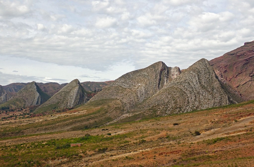
This exposed limestone was once the floor of a shallow sea. The overlying strata, here buried in sediment at the foot of the tilted slabs, are full of countless dinosaur tracks waiting to be revealed.
The following Google Earth image shows the synclinal valley in context. The bluish triangles at the lower right are the tilted limestone slabs.

The road was blocked by a flock of quadrupedestrians and their bipedal owner.

The old woman did not deign to offer a backwards glance. “We Quechua were here long before some impatient asshole with a car full of tourists, so you will just have to wait!” How many miles a day does this old shepherdess walk? How many times around the globe have her perambulations taken her?
The road continued up and up until it leveled out on a ridge at 12,000 feet where the air was cold and thin!

The views were magnificent, and the mountains appeared to go on forever.
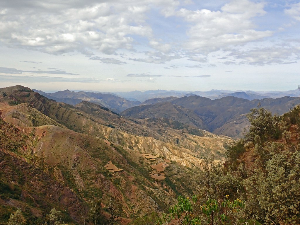
Such a rugged land would seem to be almost uninhabitable, and certainly unfarmable, but look closely at the center of the photo above. There you see the patchwork fields of an indigenous farmer whose way of life has remained unchanged for more than a millennium. Compare that to the life of a fat Redneck who sits in the air conditioned cab of a laser guided tractor while listening to right wing radio and entertaining fantasies about how, “A country boy can survive”.
After parking we began the trek to the so called “ciudad”, which was actually just a highly eroded spur of the mountain, but a beautiful place nonetheless.
Along the way there were shown petroglyphs left by the ancients, but none were comprehensible. Each and every squiggle had been conflated into a legend involving a beautiful princess, Pachamama, etc., which led me to the conclusion that Torotoro must have an imaginative tourism director.
The trail was fairly easy, but the air was so thin at 12,000 feet that I had to take a breather. Could it be that I am getting too old for such things? No way Jose!
The top of the spur was an open expanse of stone with deep crevices that we were careful to avoid.

Other than soaring condors one would expect to see little life in such a barren landscape, so we were surprised to find what appeared to be a rabbit but wasn’t.

The viscacha looks and acts exactly like a rabbit, but with a long tail. Unlike rabbits, which are Lagomorphs, viscachas are proper rodents closely related to chinchillas.
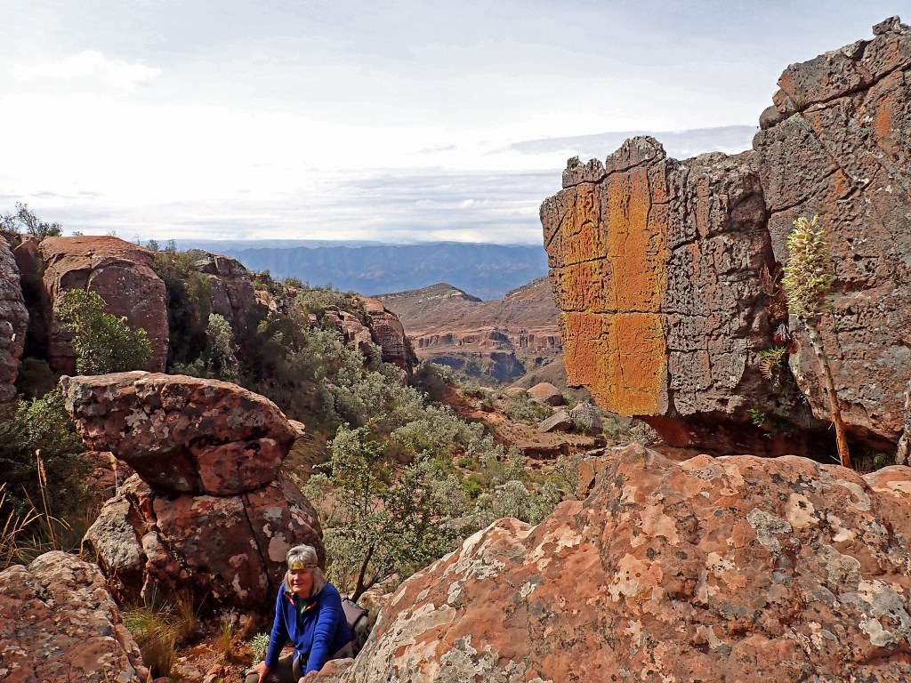
As we approached the forward edge of the spur we began to see strange vertically eroded crevices.
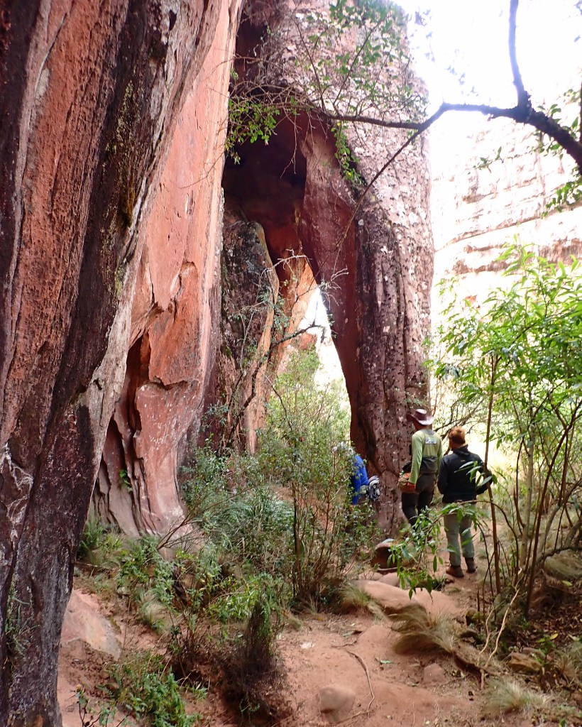
These soon opened into chambers, many of which contained petroglyphs.

Many of these spaces were dark, and appeared to be caves; but, as you can see in the photo below, each dome is developed beneath a small surface crack.

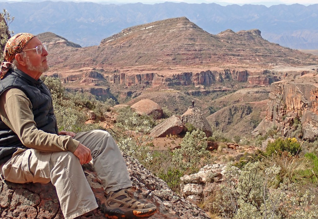
The individual chambers coalesced into a magnificent series of interconnected rooms that resembled a vaulted cathedral. This was Ciudad de Itas, a fitting abode for the gods.

I was initially at a loss to explain the geomorphosis of these strange bottle shaped voids best described as pseudokarst. Solution appeared to play a part, for each of the spaces was developed beneath a surface crevice, but this was not easily soluble limestone. To the untrained eye the mother rock on this ridge high above Torotoro may look like sandstone, but in fact it is pyroclastic volcanic debris known as “tuff”.
I have often seen vertical limestone caves which bell out beneath the surface; but, other than in the Andean pre-cordillera, I have never seen such features in otherwise insoluble volcanic rock. It may be that such deposits are simply rich in calcium, but if so where are the secondary speleothems?
Many volcanic deposits harden upon contact with air and water. It isn’t a simple matter of cooling, but rather progressive chemical change. It is a complex phenomenon that geo-geeks can explore further in a Wiki article about case hardening in rocks.
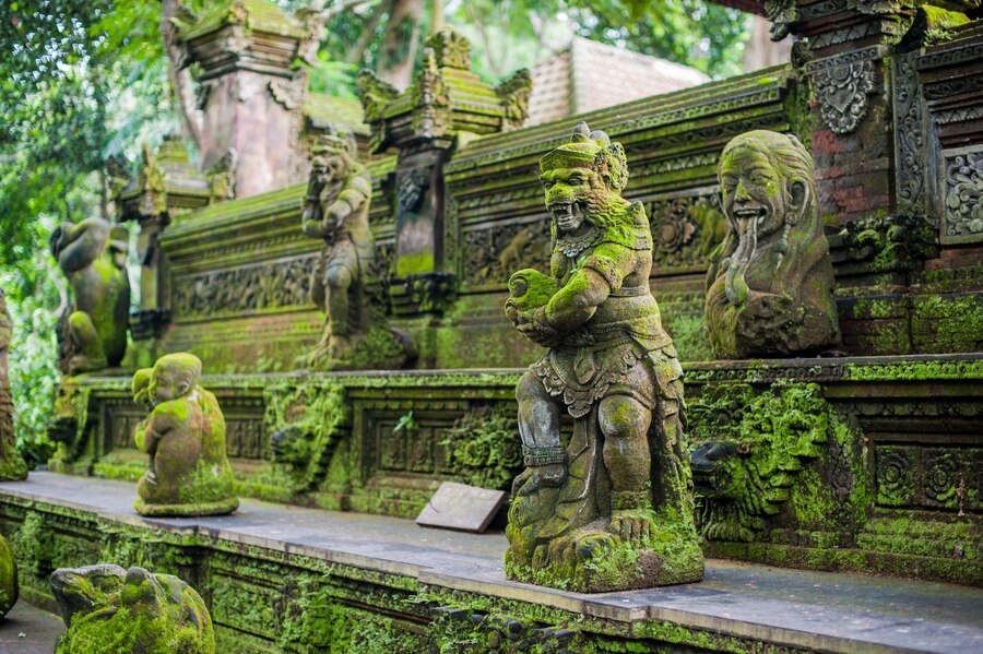
For example, the volcanic island of Bali has a crusty exterior, but the subsurface deposits are so soft they can be carved with a butterknife. This has enabled generations of indigenous artists to easily carve the soft dirt like material into beautiful sculptures that subsequently harden into stone upon exposure.
Think of it as a loaf of bread with a hardened crust and a softer interior which slowly hardens as the bread goes stale. This is the opposite of the way most sedimentary rocks form, in which the upper sediments remain soft whereas the more deeply buried strata become progressively hardened and consolidated due to heat and pressure.
Perhaps something similar is happening here. If the top crust is as hard as a proverbial rock, then becomes gradually softer with depth, these vaulted rooms may simply be due to mechanical erosion by rivulets of water, not by solution. If any of you volcanologists out there know the answer please let me know!
………………………………………………………..
So far so good, but Ciudad de Itas wasn’t a “real” limestone cave. For that we had to go to the Caverna de Umajalanta which is much closer to Torotoro. The site has been developed as a regular tourist attraction complete with a fancy restaurant. Our guide Johnny urged us to pig out and spend lots of money, but no one was interested. We even declined to see more dinosaur tracks because we wanted to get dark!
From the deck of the restaurant we had an expansive view of the Torotoro valley.

The restaurant was well designed and architecturally appropriate, but no one was interested. Instead, all the tourists were fascinated by the proprietor’s house next door. It was a simple mud brick hut with a straw roof.

People in so called “third world” countries are both amazed and appalled that tourists will come from halfway around the world to see a mud hut, then scorn their best efforts to showcase modern improvements. Most are merely amused, but those indigenes who have been contaminated by modern leftist thought are often deeply offended by tourists who, “gawk at us as though we were monkeys in a cage”. The simple truth is that everyone wants to see something different. For an affluent tourist nothing could be more different than abject poverty, so they are enamored of the rustic lifestyle until it’s time to use the toilet.
After walking about a kilometer we reached a park checkpoint, and a bodega where we were given headlamps, helmets, and rubber boots. Dr. Ann and I, of course, had our own lights and boots.
A short walk took us to the spectacular entrance of the Caverna de Umajalanta. The entire cave is developed within a bedding plane. The confining layers 0f impermeable rock above and below the soluble limestone can easily be seen here, as can the dip, which is the direction and angle at which the stratum slopes. With a steep dip of nearly 45 degrees, and a stream which runs throughout, the cave could be a death trap in the event of a heavy rain.
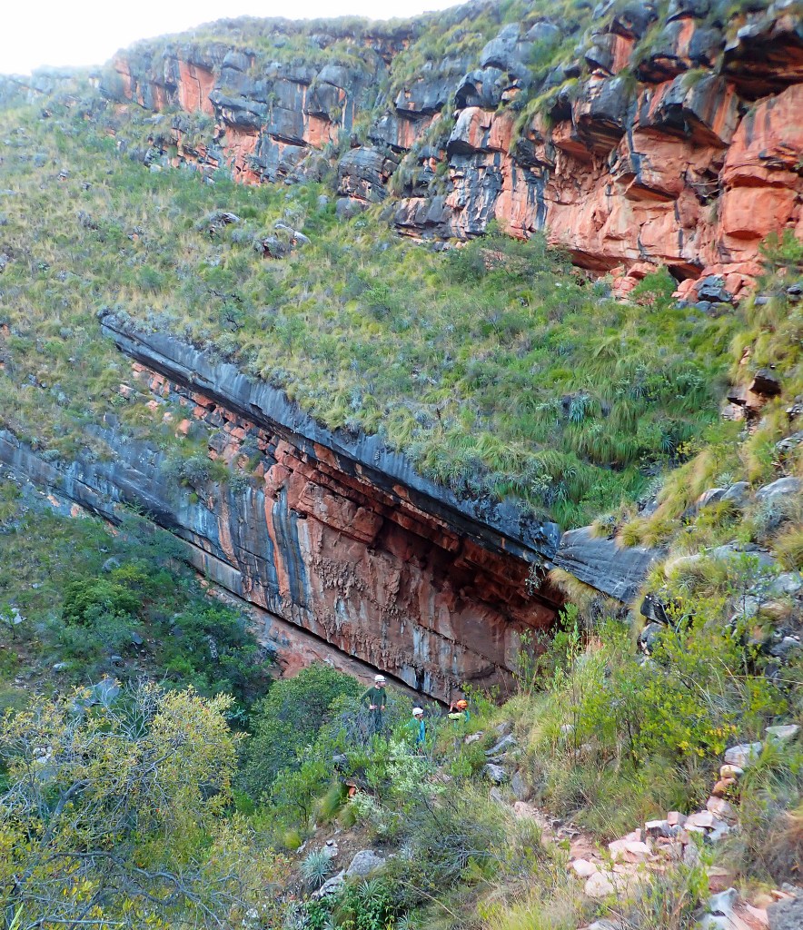
It is unusual for such a large cave to have an effectively flat roof, proof that the upper confining layer, the edge of which is here stained black by desert varnish, has great tensile strength. Had it not, the cave would long ago have collapsed.
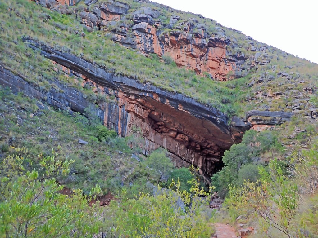
The entrance was so big that light penetrated far within.

Dr. Ann was in her element, for she loves caves.

We soon reached a short drop off where a handline had been rigged.

Our guide helped the others down the drop, but I was unable to go any further because of my injured shoulders. That was OK with me. I have been into countless caves, and have observed that all are dark, rocky, and full of mud. It was enough to bask in the stygian gloom while waiting for Ann and the others to emerge from the underworld. Aside from all that, here’s a word to the wise from the Weazel: Never ever trust a handline, especially if it has been rigged by someone else!
While waiting I scouted around for cave biota but found nothing. There are said to be blind catfish Trichomycterus chaberti, and various troglobitic invertebrates.
I find it extraordinary that there are blind fish in Torotoro. I had previously presumed that there were no fish of any kind this high in the Andes. Other than introduced trout, I have yet to see a single fish in any of the upland streams I have visited. Such streams drop thousands of feet over sheer waterfalls, and often run dry, so how could catfish have gotten there in the first place?
There have been several expeditions to Umajalanta. It apparently extends for almost three linear miles to the northeast, and the waters presumably emerge somewhere in the Torotoro canyon discussed in a previous post. More about those expeditions, and a list of known caves in both Peru and Bolivia, may be found here.
So the big question is why there are no other known large caves in Bolivia? There is another sink just north of Umajalanta which is presumed to be hydrologically connected but is unenterable. This is only one of many such potential cave entrances in the Torotoro area, but what about the rest of Bolivia?
I believe that Bolivia is a dark zone for known caves not because of a lack of limestone, but simply because it is a big wild place with much left to discover.
In the the final essay of this series I will reveal a mysterious sinkhole that I later discovered in a remote part of the Gran Chaco in southeastern Bolivia.
For now, stayed tuned for our final adventure in Torotoro in which I discover a lost Inca highway!
………………………………………
Correction! (Posted 2023/12/25:
The Weazel completely blew it in regard to the geology of the Ciudad de Itas.
Thanks to Bruce Rogers, a real geologist, I now realize that all of it was formed in sandstone, not tuff, a fact that should have been obvious to me since it looked and acted exactly like sandstone.
